IROS 2026

Mag4D-SLAM Dataset:
A Repeated-Traversal Multi-Modal
4D Geomagnetic Dataset for Localization and Mapping

The first robotics-oriented benchmark for geomagnetic-aware SLAM with structured repeated-traversal trajectories

Bibhutibhusan Nayak* Hyoseok Ju* Giseop Kim
Daegu Gyeongbuk Institute of Science and Technology (DGIST)
*Co-first authors  ·  Corresponding author
📄 Paper 💻 GitHub 📥 Download Dataset

Abstract

Simultaneous Localization and Mapping (SLAM) is a fundamental capability for autonomous robotic systems operating in complex and large-scale environments. The geomagnetic field—despite being globally available, infrastructure-free, and inherently absolute in orientation—remains largely absent from robotics-oriented SLAM benchmarks. To address this gap, we introduce the Mag4D Dataset, a multi-modal geomagnetic benchmark specifically designed for magnetic-aware localization and mapping research. The dataset provides time-synchronized measurements from LiDAR, camera, IMU, tri-axis magnetometer, and GPS sensors, together with LiDAR–IMU-based ground truth alignment. Unlike prior magnetic datasets that focus primarily on indoor anomaly localization, Mag4D emphasizes structured geometric trajectories including circular and rectangular paths recorded across seven repeated traversals of identical routes—enabling quantitative evaluation of global yaw drift, cross-session heading consistency, magnetic map stability, and alignment error under identical spatial constraints. The dataset includes both daytime and nighttime recordings on the campus, providing a controlled yet realistic outdoor benchmark for multi-modal SLAM evaluation.

Key Contributions

🧲

4D Geomagnetic Sensing

Continuous tri-axis magnetic field measurements (Mx, My, Mz) captured as a function of time along spatial trajectories, enabling joint spatial–temporal magnetic field analysis.

🔁

Repeated-Traversal Design

Seven sequences recorded over identical paths enable systematic investigation of magnetic repeatability, heading-dependent variation at identical spatial locations, and the quantitative impact of geomagnetic cues on yaw drift mitigation.

🌗

Day & Night Conditions

Paired daytime and nighttime sessions allow controlled analysis of heading robustness under illumination transitions—a scenario absent from existing magnetic-aware benchmarks.

📍

High-Accuracy Ground Truth

Precise 6-DoF ground truth poses generated by registering LiDAR scans against a high-accuracy reference map via ICP, with static validation showing standard deviation below 3 cm.

🏗️

Structured Geometric Trajectories

Circular and rectangular paths with mild elevation changes around the campus provide structured outdoor benchmarking suited for global heading and loop-closure evaluation.

📡

Full Multi-Modal Synchronization

Hardware-synchronized LiDAR, camera, IMU, magnetometer, and GPS streams timestamped to a common system clock, with temporal offsets calibrated by minimizing angular velocity residuals.

Dataset at a Glance

14 Sequences
>18 km Total Path Length
5 Sensor Modalities
Day+
Night
Lighting Conditions
200 Hz IMU Rate
6-DoF Ground Truth

Sensor Suite

Sensor Model Rate Specifications
📷 Camera Gemini 336L 30 Hz Depth 1280×800, H90°/V65°; RGB 1280×800, H94°/V68°
🔵 LiDAR Mid-360 10 Hz 360°/59° FOV; 200k pts/s; 70 m range
📐 IMU Mid-360 (built-in) 200 Hz 3-axis Gyroscope; 3-axis Accelerometer
🧲 Magnetometer 3DM-GX5-AHRS 100 Hz 3-axis; ±8 Gauss; Temperature compensated
🛰️ GPS EVK-F9P 1 Hz Multi-band GNSS receiver; Operated in standalone mode (~meter-level accuracy)

Sensor Extrinsics

All transformations are defined with LiDAR as the base frame · Tlidar←sensor
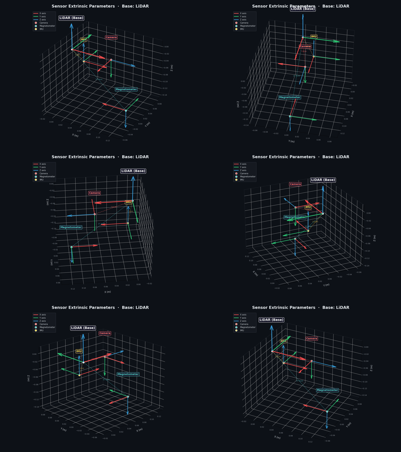
Sensor extrinsic coordinate frames animated 360° view

RGB axes = XYZ  ·  Dashed lines indicate sensor offsets from LiDAR origin

# ==============================================================
# Sensor Extrinsic Parameters (Base Frame: LiDAR)
# ==============================================================

# 1. Camera → LiDAR
T_lidar_camera: [
   0.0062967,  0.0002136,  0.9999802,  0.0720748,
  -0.9999516,  0.0075562,  0.0062949,  0.0193199,
  -0.0075547, -0.9999714,  0.0002611, -0.0151779,
   0.0,        0.0,        0.0,        1.0
]

# 2. Magnetometer → LiDAR
T_lidar_mag: [
  -1.0,  0.0,  0.0,  0.115,
   0.0,  1.0,  0.0,  0.0,
   0.0,  0.0, -1.0, -0.13,
   0.0,  0.0,  0.0,  1.0
]

# 3. IMU → LiDAR (Livox Mid-360 Factory Spec)
T_lidar_imu: [
   1.0,  0.0,  0.0,  0.011,
   0.0,  1.0,  0.0,  0.02329,
   0.0,  0.0,  1.0, -0.04412,
   0.0,  0.0,  0.0,  1.0
]
📷 Camera
7.6 cm
🧲 Magnetometer
17.4 cm
📐 IMU
5.1 cm

Sequences

14 sequences · 3 environments · day & night · forward & reverse traversals

Sequence Env. Light Direction Path (m) Duration (s)
Campus
campus_day_fwd_01 Campus ☀️ Day → Fwd 1382.9 1203.8
campus_day_fwd_04 Campus ☀️ Day → Fwd 1554.1 1291.9
campus_day_fwd_08 Campus ☀️ Day → Fwd 1465.6 1181.2
campus_day_fwd_09 Campus ☀️ Day → Fwd 1443.6 1132.3
campus_day_rev_05 Campus ☀️ Day ← Rev 1637.2 1299.1
campus_day_rev_07 Campus ☀️ Day ← Rev 1605.3 1234.9
campus_night_fwd_00 Campus 🌙 Night → Fwd 1376.6 1117.3
campus_night_rev_11 Campus 🌙 Night ← Rev 1527.3 1224.4
Circle
circle_day_fwd_rev_02 Circle ☀️ Day ↔ Fwd+Rev 1119.1 822.1
circle_day_fwd_rev_06 Circle ☀️ Day ↔ Fwd+Rev 987.5 763.0
circle_day_fwd_rev_10 Circle ☀️ Day ↔ Fwd+Rev 1402.8 993.2
circle_night_fwd_rev_00 Circle 🌙 Night ↔ Fwd+Rev 1064.4 816.9
Library
library_day_fwd_03 Library ☀️ Day → Fwd 189.5 163.3
Campus + Circle
campus_circle_night_rev_12 Campus+Circle 🌙 Night ← Rev 1676.0 1406.2

Comparison with Existing Datasets

Year Dataset Seq. Avg. Length Mag. Day/Night Precise GT
2013 KITTI 22 ~2 km
2016 EuRoC 11 ~80 m
2017 RobotCar 100+ ~10 km
2017 MagPIE 10 ~500 m
2018 TUM VI 28 ~200 m
2020 Newer College 4 ~1.5 km
2021 MagWi 100+ Indoor multi-floor
2023 Boreas 40+ ~8 km
2025 GrandTour 49 >10 km
2026 Mag4D (Ours) 7 ~1.3 km

Data Format

Directory Structure

Mag4D/
├── campus_day_fwd_01/
│   ├── raw.bag      # All ROS topics
│   ├── imu.csv      # IMU data
│   ├── mag.csv      # Magnetic field
│   ├── gps.csv      # GPS positions
│   ├── gt_pose.csv  # Ground truth poses
│   ├── map.pcd      # Global LiDAR map
│   ├── lidar/       # Point clouds
│   └── images/      # Camera frames
├── campus_day_fwd_04/
│   └── ...
├── campus_night_fwd_00/
│   └── ...
├── circle_day_fwd_rev_02/
│   └── ...
├── library_day_fwd_03/
│   └── ...
└── ...              # 14 sequences total

ROS Topics

/imu/data Linear acceleration and angular velocity
/imu/mag Tri-axis magnetic field (Mx, My, Mz) in µT
/lidar/points 3D LiDAR point clouds (PCD format)
/camera/image_raw Monocular RGB images
/gps/fix GPS position measurements
/tf Coordinate frame transformations

Citation

@inproceedings{nayak2026mag4d,
  author    = {Nayak, Bibhutibhusan and Ju, Hyoseok and Kim, Giseop},
  title     = {Mag4D-SLAM Dataset: A Repeated-Traversal Multi-Modal 4D Geomagnetic Dataset for Localization and Mapping},
  booktitle = {Proceedings of the IEEE/RSJ International Conference on Intelligent Robots and Systems (IROS)},
  year      = {2026},
  note      = {to appear, arXiv preprint arXiv:2607.21986}
}